
ARSE Digest 4: The Most Juicy Space Pics Of The Week!
The ever increasing threat of climate change spurs the erratic weather in the northern hemisphere this week, the Hubble does what it does best in peering into the soft spots of gassy giants, there's lasers, and a pretty neat space pic of somewhere close to home.
That's what's inside this weeks ARSE digest.
Have fun!
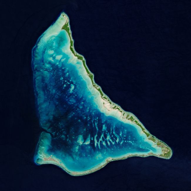
Ain't No Amoeba.

Image credit: contains modified Copernicus Sentinel data (2020), processed by ESA, CC BY-SA 3.0 IGO.
We can understand your confusion if you thought as much, but this is the top-down-view of the remote island nation of Tarawa Atoll within the Republic of Kiribati.
Kiribati is made up of 3.5 million square kilometres of the Pacific ocean with just 800km of landmass, as shown by this image from the Copernicus Sentinel-2 mission.
Red Raw Close-Up Of Enceladus
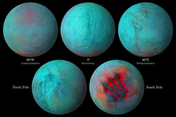
Image credit: NASA/JPL-Caltech/University of Arizona/LPG/CNRS/University of Nantes/Space Science Institute.
This global infrared 'mosaic' of Saturn's moon Enceladus is from Cassini spacecraft data during its lengthy mission from 2004 to 2017. Fresh ice is coloured red in its southern pole and appears to be connected to the moon's subterraneean ocean beneath its surface. The different aspects of the moon shown in infrared are; the planet facing side, its farthest side, and the two poles.
Freakin' Laser Beams! (Not Really)

Image credit: ESO/P.Horálek
The Very Large Telescope or VLT is so large that the pictured unit is just number 4 and named justly. The Unit 4 Telescope (shown) is one part of the planet-sized telescope network that makes up the VLT.
Unit 4 is firing its "laser guide stars" into the night sky to calibrate its adaptive optics system against the distortion of the Earth's atmosphere.
Jupiter's Southern Sore Spot

Image credit: NASA, ESA, STScI, A. Simon (Goddard Space Flight Center), M.H. Wong (University of California, Berkeley), and the OPAL team
The Hubble Space Telescope captured our Solar System's largest gas giant in scintillating detail on August 25th. Complete with wind bands that cross the planet and its iconic Great Red Spot.
Turbulent Northern America
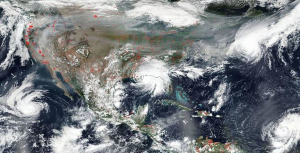
Image credit: NASA Worldview, Earth Observing System Data and Information System
The natural impact of the United States caught by NASA's Aqua satellite, including six tropical storms and over 100 raging wildfires at the time of capture (September 15th).
The storms captured off the Gulf Coast were Paulette, Rene, Teddy and Vicky in the Atlantic Ocean and Karina in the Pacific. The wildfires are not named.
Cheers for another great week in space.
If you have any feedback or want to engage in lukewarm banter with fellow astronerds, jump into out official Australian Space Society here.
Or if you haven't spread ARSE with your gear yet, grab some here!


