
Retreating glaciers and eroding coastlines - Google Earth is showing us how the planet is changing over time.
Google added a fourth dimension to their 3D mapping tool available on desktop or mobile devices on Thursday. And now timelapse videos can show a different perspective on the world with 24 million satellite photos from the past 37 years stitched together.
According to Google Earth director of Earth Engine & Outreach, Rebecca Moore:
“Google Earth newest Timelapse feature lets users look back from the current day all the way to 1984 and see how both human activity as natural forces have changed the face of Earth over the last 40 years”
Some Timelapse videos show retreating in Alaska while others show suburban sprawl taking over the Las Vegas desert or farms developing in Saudi Arabia.

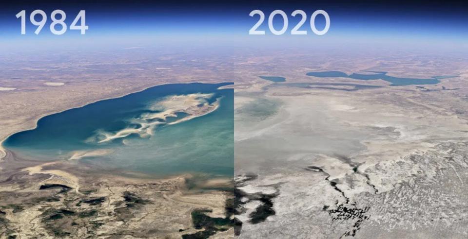
Here is a timelapse comparison showing the changing Aral Sea, Kazakhstan. Once the world's fourth-largest body of inland water, the lake has shrunk after the rivers that fed it were diverted by irrigation projects.
NASA and the U.S. Geological Survey, with the European Union’s Copernicus program, worked together to develop a fuller picture of Earth from 1984 through 2020 using satellite imagery and data. Where a single computer would have taken 228 years to process the millions of images used, the program made it happen in just a few days.
You can access Timelapse videos for any location at g.co/Timelapse or click on the ship wheel icon in the application to see curated "tours" or stories from selected locations around the globe.
Google Earth focused its stories on forest change, urban growth, warming temperatures, mining and renewable energy sources, and the world's fragile, changing beauty.
The best way to view Timelapse videos for any location is through g.co/Timelapse or click on the ship wheel icon in the application to see curated "tours" or stories from selected locations around the globe. Google Earth has 800 Timelapse videos available for anyone to download at g.co/TimelapseVideos or to watch on YouTube.
The Google Maps team has produced a series of video animations that highlight some of the areas of geological interest:
The 1991 eruption of Mount Pinatubo in the Philippines resulted in decades of mudflows from the large amounts of ash and rock that was deposited.
Chugach Mountain glaciers flow into a narrow fjord leading into Prince William Sound in southeastern Alaska. British explorers first surveyed it in 1794, its terminus extended south to the northern edge of the drowned glacial valley. The glacier held that position until 1980 when it began a rapid retreat that continues today.
The shifting coastline around Chatham, Massachusetts. The changes to the sandbars are sometimes subtle and sometimes dramatic. Storms cut new inlets through the beach, changing current patterns and subsequent erosion and deposition of sediments.
A timelapse look at the changing Aral Sea, Kazakhstan. The lake was once the world’s fourth-largest body of inland water but has been shrinking since the 1960s after the rivers that fed it were diverted by irrigation projects.
Open-pit mine in a coal mining district in southern Brandenburg. As Germany's black coal industry shuts down, mines turn into lakes and new ecologically valuable biotopes.
The new imagery is free to access and use, like the rest of Google Earth, and will be updated annually.


